Iowa State University’s Center for Earthworks Engineering Research (CEER) recently received national recognition for roadway flood damage research.
The American Association of State Highway and Transportation Officials (AASHTO) identified an Iowa State research project, “Western Iowa Missouri River Flooding – Geo-Infrastructure Damage Assessment, Repair and Mitigation Research,” as a 2014 Sweet 16 High Value Research Project. CEER Assistant Director Pavana Vennapusa, Richard L. Handy Professor David White and former Assistant Scientist Kelly Miller conducted research and compiled the report.
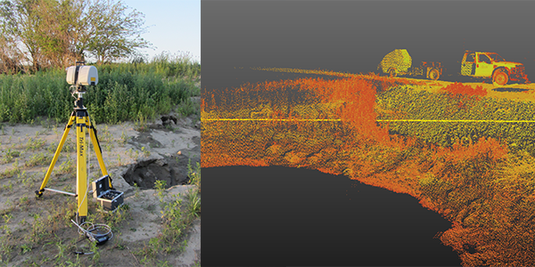
Western Iowa levees, bridge abutments/foundations, paved and unpaved roadways, culverts, and embankments – geo-infrastructure – were damaged from the 2011 Missouri River flood. Iowa State was awarded a 2-year project, sponsored by the Federal Highway Administration and Iowa Highway Research Board, to assist western Iowa counties in rapidly assessing damage and performance of secondary roadways by deploying and using advanced technologies and to develop recommendations for use during future flood events.
Field performance test results indicated significant differences in roadway support characteristics between flooded and non-flooded areas. Voids were found in bridge abutments several months after flooding, due to erosion. Researchers recommended geotechnical assessment, repair, and mitigation methods based on the different types of flood damage and infrastructure.
Read the full project report. CEER also compiled a project summary, which you can read here.
Each year, AASHTO collects high-value research highlights from state transportation departments across the nation to showcase projects that provide transportation excellence through research. This year, AASHTO received more than 100 nominations. Regional AASHTO committees then selected four from their regions to comprise the Sweet 16. Read the list of 2014 Sweet 16 projects at www.aashtojournal.org/Pages/072514Sweet16Projects.aspx.